
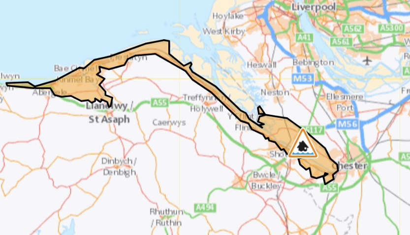
A flood alert has been put into effect immediately for a vast stretch of the North Wales coastline, from the Dee estuary to Anglesey, as the region braces for the impact of Storm Gerrit.
The alert comes amid rising concerns over potential flooding caused by high tides, expected to peak at 11.30pm on Wednesday, 27 December 2023.
Natural Resources Wales is closely monitoring the situation, particularly focusing on the flooding of low-lying lands and roads.
Local communities, especially those situated near the coast, have been advised to stay vigilant and prepare for necessary precautions.
In addition to the high tide, Storm Gerrit brings with it high winds and heavy rain, compounding the risk of coastal flooding.
The Met Office has issued a yellow wind warning that encompasses all of Flintshire, North Wales, and the Northwest of England.
The warning is in effect from 6pm this evening through to 3am on Thursday.
Frank Saunders, Chief Meteorologist at the Met Office, highlighted the potential impacts of Storm Gerrit, noting:
“Winds across southern coastal areas of England will be strong, possibly peaking around 70 mph on exposed coastlines, but more widely around 50-60 mph within the warning area.”
NRW emphasises the importance of staying away from beaches, promenades, coastal footpaths, and roads that are at high risk of flooding.
The agency also cautions that sea spray and waves could be dangerous during this time.
The Met Office warnings highlight potential disruptions to transport, power cuts, and flooding in some areas.
Residents and visitors are urged to stay up-to-date with the latest warnings and advisories.
The combined effect of high tides and Storm Gerrit’s severe weather conditions requires a heightened level of preparedness and caution from all affected by the warning area.
 Blues News - 1985/86 squad to reunite on Saturday
 Warning after rising attacks on sheep in Cheshire
 Road safety operation launches to keep road users safe
 Cheshire bucks the national trend in tackling shoplifting
 Countess of Chester Hospital reports strong early use of new rapid‑review hotline
 Befriending Service Launches to Tackle Loneliness Across Cheshire West and Chester
 Help Shape Support for Unpaid Carers in Cheshire West and Chester
 CHESTER CHOIR TO BE JOINED BY NORTHUMBERLAND CONCERT BAND FOR TOWN HALL CONCERT
 CHESTER THEATRE DEBUT FOR 'COME FROM AWAY' MUSICAL AT STORYHOUSE
 In Memory of Councillor Stuart Parker MBE, 1950 – 2026
 Connah's Quay Artist Gains Momentum with England World Cup Anthem
 Blues Match Report: Macclesfield 0 - 2 Chester
 Blues Match Preview: Macclesfield v Chester
 Blues Match Report: Chester FC 2 - 1 AFC Telford United
 Blues Match Preview: Chester FC v AFC Telford United
 Police launch campaign urging drivers to wear a seatbelt on every journey
 Serial car thieves jailed after stealing cars across Cheshire and North Wales
 One of the world's tiniest antelopes has been born at Chester Zoo
Comments
Add a comment