
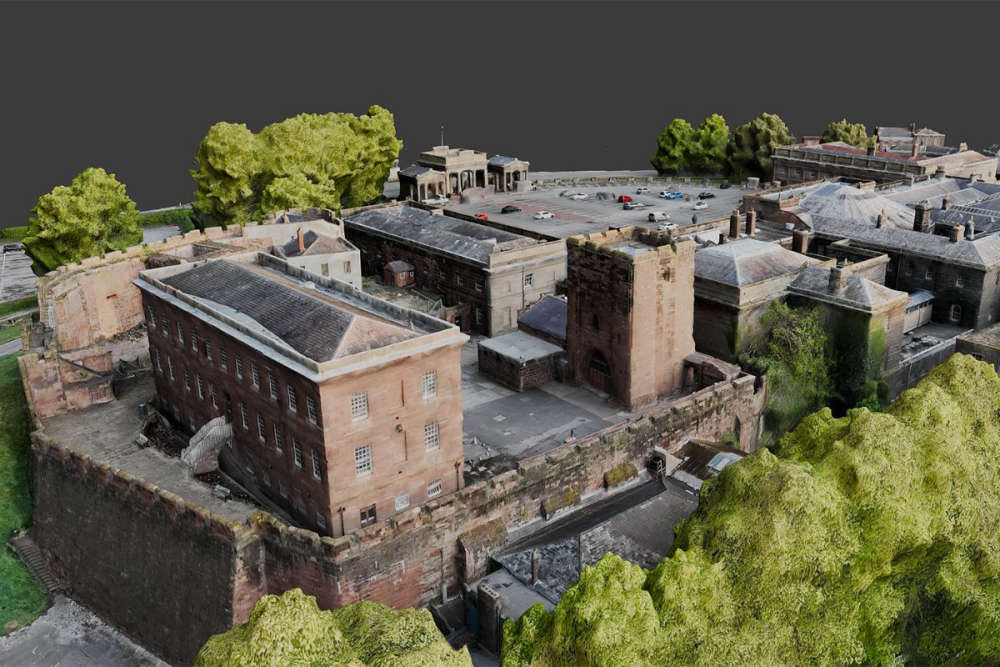
A project to capture an iconic Chester city centre landmark in new levels of detail with the help of a Time Team expert could help combat heritage crime.
The ground-breaking Digital Dimensions Project at Chester Castle, led by University of Chester team Stewart Ainsworth (Time Team’s Landscape Archaeologist and Visiting Professor of Landscape Archaeology), Professor Meggen Gondek and Alex Foster (Digital Specialist), brings together representatives, resources and skills from the University, English Heritage, Historic England and Cheshire Police Rural Crime Team.
The project could shed new light on Chester Castle’s origins and lead to the innovative methods being used more widely at other heritage sites to promote conservation and limit heritage crime. Some of the digital models and imagery can also be displayed more widely for the benefit of students and schools, while also promoting wider outreach opportunities for digital exploration of the castle via the internet and English Heritage.
It uses latest-generation drones with light detection and ranging data (LIDAR) and imaging sensors to generate a survey of the whole castle complex. Additionally, there will be targeted surveys of areas of specific archaeological and/or architectural interest for more detailed scanning to generate 3D models and images in detail never seen before.
Such methods allow a detailed survey and analysis to be undertaken in a non-invasive way, thereby recording and preserving the castle complex without damaging any of the structures. The analysis of the results will help contribute to its long and complex history through its many physical changes over the centuries, as well as inform conservation and preservation of its structures.
This new project builds upon pioneering work undertaken by Stewart and colleagues from the University in 2024, in a collaboration with Forestry England and Historic England, using LIDAR and other remote-sensing techniques to investigate a scheduled medieval glassworks at Glaziers’ Hollow in Delamere Forest, which is on the Heritage at Risk Register.
Following that work at Delamere and other sites in Shropshire, Stewart was approached by Cheshire Police Rural Crime Team to see if the methods used to document the landscape could record and investigate damage or threats to heritage assets elsewhere. Use of the drones and scanners would allow remote-sensing surveys to be carried out and generate a snapshot of what heritage assets look like at a particular point in time, making it easier to detect any unwarranted changes such as theft and/or vandalism.
New methods of analysing the impact of damage to assets are also being evaluated as part of this project. This is particularly relevant in the wake of the widely reported Sycamore Gap crime which has highlighted the value placed on cultural assets.
Stewart said:
“Chester Castle has been a centre of regional power, justice and administration for centuries, yet it remains one of the city’s least understood heritage assets. This new collaborative project will not only benefit Chester, it will also make it known to a much wider audience through the power of digital outreach, as well as contributing to the protection of other cultural assets.”
The University research project is complementing survey work already undertaken by Historic England at the Agricola Tower, where the High Sheriff of Cheshire, Joëlle Warren MBE, visited to learn about the exciting developments.
The High Sheriff said:
“On a recent visit to Chester Castle, I met with Cheshire Police, English Heritage and the University of Chester who are working together to tackle combat heritage crime using leading-edge 3D imaging software. It’s always exciting to see true collaboration between organisations and the difference this can make in our community.”
Win Scutt, Curator of Properties at English Heritage, said:
"Chester Castle stands as a pivotal monument in medieval English history, serving as a key Norman stronghold, administrative centre for the Earldom of Chester, and a crucial military base for campaigns against Wales.
“The ongoing digital scanning and research are of immense importance, as they allow for the creation of incredibly precise 3D models and detailed documentation, safeguarding this invaluable heritage for future generations and enabling unprecedented opportunities for conservation, study, and public engagement."
PC Jonathan Lightfoot, Heritage Crime Officer and Wildlife Crime Officer for Cheshire Police Rural Crime Team, added:
“This is a fantastic opportunity to see what modern technology can be used to both detect and prevent heritage crime.
“Being able to have 3D models and maps of crime scenes can really assist use with investigations. We have already seen what evidence can be produced from some of the tests we have done and it is really exciting.”
Pictured - 3D scans generated of the Chester Castle area.
 Continued parking chaos at Wrexham Maelor Hospital
 Residents invited to have their say on draft Transformation Strategy
 Family of "beautiful" son who died following Chester collision pay tribute
 Chester and Wirral Football League - Weekend Round Up
 Back to the Future event to be held at Picturehouse Cinema
 Children and families in Cheshire to benefit from new Child Focused Courts approach
 Residents invited to help shape the future of Whitby Park
 WREXHAM COMMUNITY THEATRE COMPANY RETURNS WITH BRAND NEW SHOW IN TIME FOR HALLOWEEN
 Blues Match Report: Lower Breck 1 - 2 Chester
 Appeal for information following serious collision in Chester
 Parents warn of “catastrophic tragedy” as school transport cuts leave 11-year-olds stranded on the A41
 Live Facial Recognition technology to be deployed in Chester this weekend
 Road to reopen as part of town centre
 £1 bus travel launched for young people across Cheshire West and Chester
 Peak Cluster carbon capture and pipeline project in Cheshire West and Chester
 Officers out in force in Blacon for Operation Decisive
 Neighbourhood Plan and Neighbourhood Development Order finalised for Blacon
Comments
Add a comment